Updated at 10:34 p.m. ET
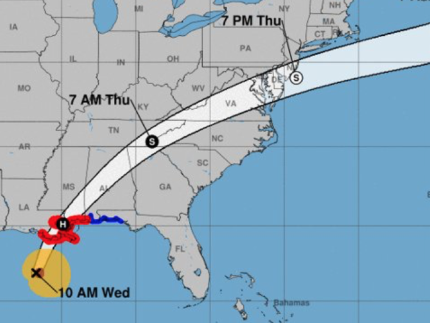
Hurricane Zeta, which made landfall as a Category 2 storm in southern Louisiana, is losing intensity on its trail of destruction over the Gulf Coast.
The storm came ashore Wednesday evening in the fishing village of Cocodrie, La., before moving over New Orleans and onto to Mississippi and Alabama.
The National Hurricane Center warns that "life-threatening surge and strong winds" continue to batter the region. Storm warnings extend through north Georgia and into the Carolinas.
At least one person died in the storm in Louisiana: a 55-year-old man who was electrocuted by a downed power line, The Associated Press reported.
An unofficial weather station near Louisiana's Lake Hermitage reported sustained winds of 64 mph and a gust to 86 mph, while an elevated station at Bayou Bienvenue reported sustained winds of 88 mph and a gust to 112 mph.
The storm has also caused massive power outages across several states. More than 556,000 customers in Louisiana lost service. In Mississippi, more than 177,000 are without power.
Zeta was anticipated to make landfall in the U.S. as a much weaker storm after first striking Mexico's Yucatan Peninsula. But by Wednesday morning it began to regain strength and intensity, striking Louisiana with maximum sustained winds of 110 mph.
By about 8 p.m. local time, the hurricane was blowing across New Orleans, knocking out power on Bourbon Street.
Electricity is out on Bourbon Street. @FOX8NOLA pic.twitter.com/sNEQMektM4
— Garland Gillen (@garlandgillen) October 29, 2020
In Grand Isle, La., roofs were ripped off of buildings, utility poles were downed and streets were completely flooded.
Grand Isle, via Dean Blanchard. pic.twitter.com/F19T66Si5p
— Councilman Scott Walker (@ScottWalkerJP) October 29, 2020
Conditions were rapidly deteriorating in Alabama and Mississippi. In its update at 9 p.m. local time, the hurricane center said several stations in the vicinity of Gulfport and Biloxi, Miss., reported winds gusts of 75-100 mph, though it noted wind speeds were now decreasing on the area.
"Zeta is no joke. It's howling," a person wrote on Twitter, posting video of flooded streets whipped by high winds in Biloxi.
Surge is really coming up in Biloxi. We are safe on third level of parking garage now and all the lights are out. #Zeta is no joke. It’s howling. @spann @FOX10News pic.twitter.com/YroOKQ4rKs
— Ryan Jackson (@RJack_5) October 29, 2020
It's yet more calamitous weather for a Gulf Coast that has already been hit hard this season by hurricanes and tropical storms. The governors of Louisiana, Alabama and Mississippi each declared a state of emergency in advance of Zeta's landfall.
Zeta is the third hurricane to make landfall in Louisiana this Atlantic hurricane season, according to meteorologist Philip Klotzbach.
By Wednesday afternoon, the National Weather Service reported that dangerous storm surge had already begun along the Gulf Coast.
#Zeta is now a Category 2 #hurricane with max winds of 100 mph - the latest Category 2+ hurricane in the western Gulf of Mexico (west of 90°W) on record. pic.twitter.com/OuvvRNsEdA
— Philip Klotzbach (@philklotzbach) October 28, 2020
Officials in New Orleans, which hasn't been hit hard by the season's earlier storms, were preparing for a strong storm. "I don't think we're going to be as lucky with this one," the city's emergency preparedness director, Collin Arnold, told CNN.
"Complete any preparation ASAP!" the National Weather Service of New Orleans tweeted. "Conditions will continue to worsen throughout the day!"
The hurricane center's Wednesday morning advisory painted a grim picture of the potential storm surge in the worst-hit areas, especially if the peak surge occurs during high tide. In Alabama, areas from the mouth of the Pearl River to Dauphin Island could see water levels rise between 6 and 9 feet. In Louisiana, areas from Port Fourchon to the mouth of the Mississippi River could see a surge of 5 to 8 feet.
"The deepest water will occur along the immediate coast near and to the right of the landfall location, where the surge will be accompanied by large and dangerous waves," hurricane center forecaster Richard Pasch said.
Officials warned that Zeta's high winds could uproot trees and power lines, damage structures and lead to flying debris. "Wind gusts can be especially severe across the southern Appalachian Mountains on Thursday," Pasch said.
Emergency resources were at the ready across the Gulf states. Perhaps Mississippi Gov. Tate Reeves summed up the general sentiment of government officials with his morning message on Twitter: "Stay sharp, stay safe, and pray for God's protection."
Copyright 2020 NPR. To see more, visit https://www.npr.org. 9(MDAxMzY2MjQ0MDEyMzcyMDQ5MzBhZWU5NA001))


